


Feature
• Preloaded digital worldwide cartography
• NAVIONICS®GOLD SD card
• Real time display of navigation information
• Updated electronic chart available
• Built-in map with range rings and 12 zoom ranges from 0.01 to 32 nm
• Cursor ID mode allows easy readout of target vessel
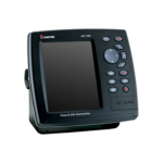
Specifications
• Size : 164 mm(H) x 183 mm(W) x 91 mm(D)
• Display : 5.6 diagonal, TFT color LED, 480 x 640 pixels
• Supply Voltage : 10 to 34 V DC
• Supply Current : 13.8 V
• Operating Temperature : -10° to 50°C
• Alarms : Arrival radius, anchor, XTE, danger, too shallow, too deep, fish, temperature, temperature rate,
low battery, low fuel(optional), loss of DGPS fix, radar guard zone, dangerous AIS vessels.
• Chart Card : NAVIONICS® GOLD
• User Card : SD Card
• Waypoints : Up to 5000, with default or user defined alphanumeric names up to eight characters.
• Routes : 100 Routes, with up to 100 points each
• Tracks : By time or distance, 10 track of 5000 points
• Chart Datums : 216 Chart datums (see next page) One user-defined map shift.
• Chart Scale : 0.2 to 500 nm for chart (chart dependent) down to 0.01 nm in plotter mode.
• NMEA : NMEA 0183 4800, 9600, 38400 baud NMEA 2000


Reviews
There are no reviews yet.